The Real data
Real data description
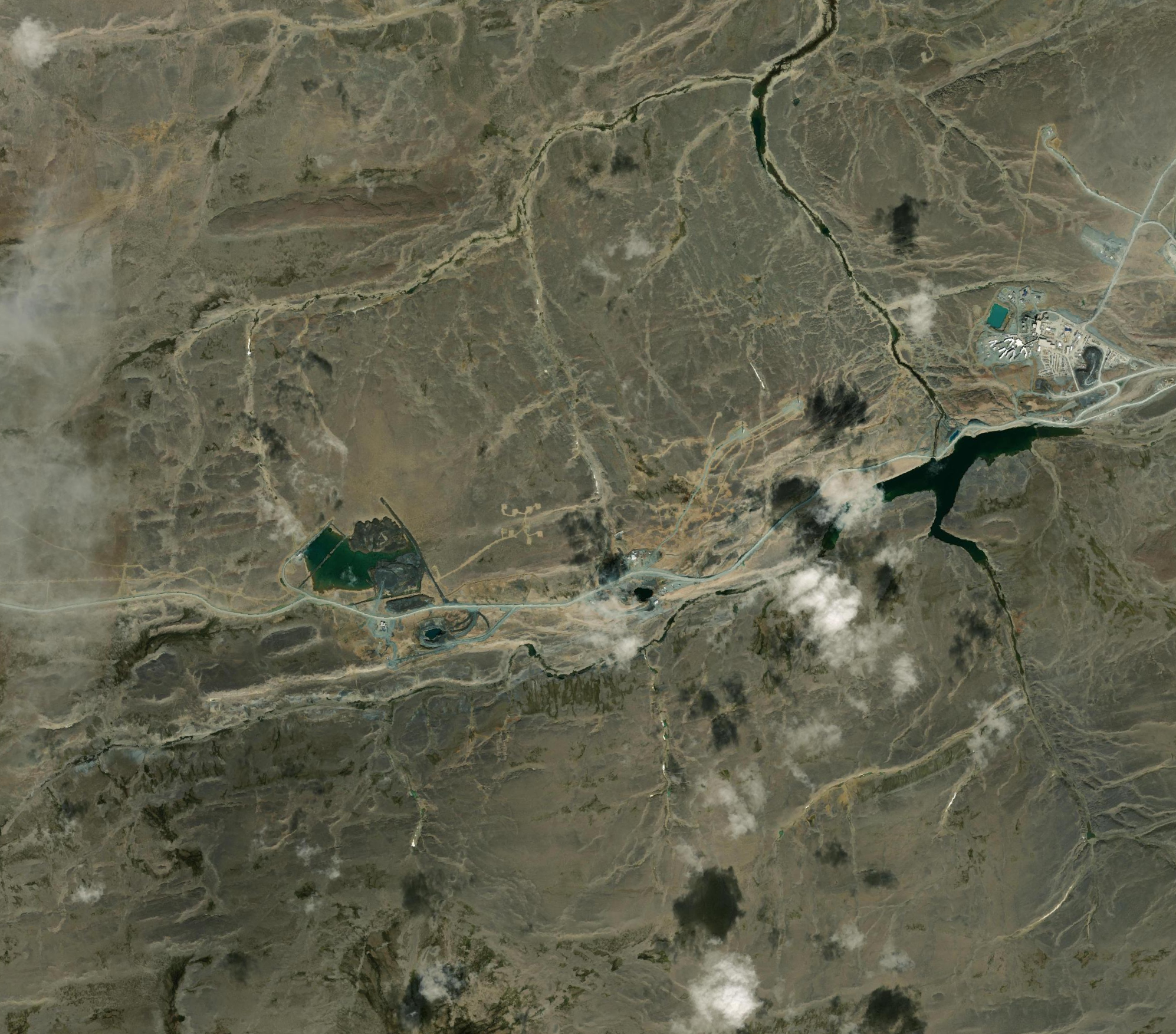
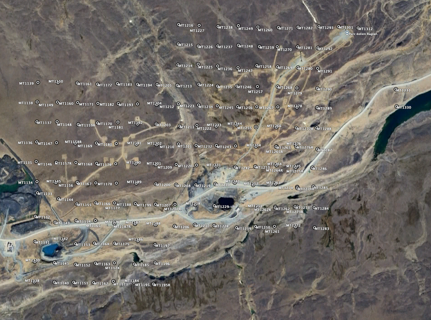
For MT3DINV4, the real data to be inverted are from Zones 2 & 3 in the Raglan mining district in northern Quebec. The data were acquired by Quantec Geoscience of Toronto in 2017, and comprise data at 164 distinct locations. Fourteen sites were repeated (denoted then an "R" in the filename), so the total number of data files is 178. For these 14 locations, you are to choose which of the two sites to use.
The data and reports are publicly available and can be viewed on the Province of Quebec's Examine web site here
The original Quantec data are in EDI SPECTRA format and can be downloaded from here.
The spectra data have been converted into RhoA/Pha estimates and their errors in J-format and can be downloaded from here.
A Quantec logistics report on acquisition is available here.
NOTE 1: These response estimates are "raw" and are unedited, and need inspecting and careful editing prior to inversion. Problems in the data if uncorrected may lead to spurious erroneous inversion model artefacts.
NOTE 2: Hz was not acquired, so there are no Tipper data. Ignore spurious Tipper values in any files.
NOTE 3: You can ignore the four sites that sit outside the main array, sites MT1301, MT1312, MT1330 and MT1331.
NOTE 4: The Datum and Projection used by Glencore at Raglan is NAD83, Zone 18N. However, NAD83 only differs from WGS84 by +0.11m Easting, -1.26m Northing, and +0.55m vertical, in the centre of the grid, so you can use WGS84 if you prefer.
Corrected (XY,YX) data description
Glencore is permitting me to release a modified version of the Assessment, Analysis and Correction report I wrote for them on these data, and also to release the corrected data after
applying the correction approach described in the report. These corrected data should not be taken as definitive - you need to decide for yourself whether to model the original data,
after your own corrections, or to model these data.
Download my Assessment, Analysis and Correction report here.
Download my corrected data in EDI format here.
Download my corrected data in J-format here.
Topography
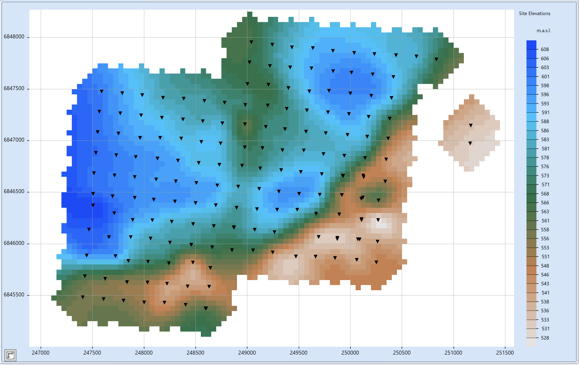
Topography varies mildly over the array from a low of 526 m to the SE to a high of 611 m to the W,
with a mean of 575 m, a median of 581 m, and Q1 and Q3 quartiles of 561 m and 592 m.
To first order you can assume a flat topography at an average elevation of 575 m.
Topography files were gratefully provided by Friedemann Samrock of Viridien.
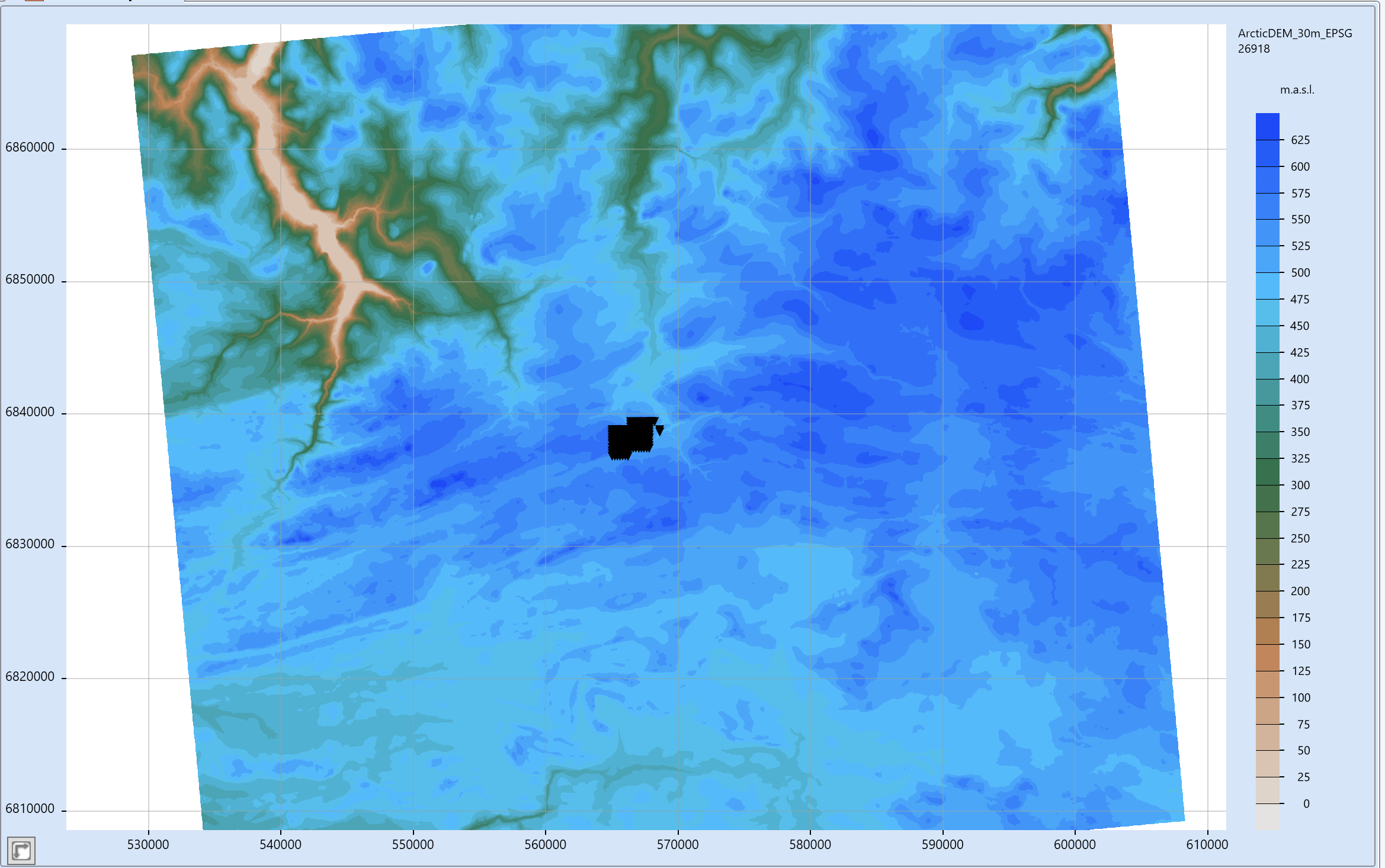
The data source is Porter, Claire, et al., 2023, 'ArcticDEM, Version 4.1', https://doi.org/10.7910/DVN/3VDC4W , Harvard Dataverse.
Distributed by OpenTopography.. Accessed 2026-05-28
Projection: EPSG:26919, NAD83 / UTM zone 19N gridded on a 30m mesh. https://epsg.io/26919
Three formats: 1) Geosoft grid, 2) Geotiff, 3) ascii XYV
NOTE: Topography was reprojected from UTM zone N19 to UTM zone N18
Download topography in Geosoft grid here.
Download topography in Geotiff here.
Download topography in xyz here (zip file).
Submitting your model and model results
Inversion model
Unfortunately, we as a community have failed to come together and agree on a universal model file format.
Here are some acceptable formats for the MT3DINV4:
- RLM: Randy Mackie format, for rectilinear meshes. Can be imported directly into Viridien's Geotools software package.
- UBC: UBC format. Can be imported directly into Geotools. Comprises two files, a 3D mesh file and a 3D model file.
- xyzv: An xyzv file is the most mesh-agnostic. Each xyzv points defines the centre of a cell at (x,y,z), of property value v. Two adjacent cells in X would have their boundary at (x1+x2)/2, same for Y and Z.
- Other formats may be added to this list.
Model responses
Please submit BOTH the data you inverted and the responses of your inversion model in EDI format.
Please include the following additional information in your submission email:
Type of code used (FD, FE, integral equation, etc.)
Computing time
Hardware details (CPU speed, memory, cluster specification)
Inversion parameters, including:
- Mesh dimensions
- Error floors assumed
- Regularization terms
- A detailed list of the inversion steps you used so what you did can be replicated by others using the same code on the same data
Site locations
Raglan Mine
The Raglan Mine is located in the Paleoproterozoic Cape Smith Belt of northern Québec, a folded volcanic–sedimentary belt formed around 2 billion years ago. The deposits occur within ultramafic rocks—primarily komatiitic and peridotitic lava flows of the Chukotat Group—which were emplaced as high-temperature magmas in a tectonically active environment.
Mineralization is of the magmatic Ni–Cu sulphide type, formed when these ultramafic magmas became sulphur-saturated, causing dense sulphide liquids to separate and accumulate. These sulphides settled at the base of lava flows and within flow channels or embayments, where they concentrated nickel, copper, and minor cobalt and platinum group elements.
The ore occurs as discontinuous lenses of massive, net-textured, and disseminated sulphides, typically located along the basal contacts of the ultramafic units. Overall, the Raglan deposits represent a classic example of komatiite-hosted nickel sulphide mineralization controlled by lava flow dynamics and structural repetition within a deformed volcanic belt.
Discussion — Real data
Questions or comments? Sign in with GitHub to join the discussion.